Exploration & Colonialism
This exhibit explores the global expansion of early modern England and its increasing engagement with the wider world through travel, trade, and exploration. During the late sixteenth and seventeenth centuries, English travelers began moving beyond Europe in search of resources, power, and new economic opportunities. These journeys were not just about discovering new places, but about creating connections between different regions of the world. Over time, these connections helped lay the foundation for England’s growing colonial empire.
One of the main ideas shown in this exhibit is that exploration happened in different ways and in different places. English exploration and colonization took place across many different regions of the world and was not just limited to one place. For example, Newfoundland became important because of its fishing resources and its location in the North Atlantic, which made it a key part of trade and travel routes. At the same time, travelers like Thomas Coryat explored regions such as India and recorded their experiences, helping shape how Europeans understood other cultures. These examples show that exploration involved more than just location, it also involved the exchange of ideas and culture.
The exhibit also shows how different types of sources can be used to understand exploration and colonialism. Some sources focus on visual representation, such as maps, which highlight geography, trade routes, and areas of economic importance. Other sources, like travel accounts or printed materials, show how people described and interpreted the world around them. For example, printed sources like newspapers helped spread information about colonies and shaped how people thought about colonialism and expansion. When looked at together, these sources provide a broader understanding of how England expanded and interacted with the wider world.
It is also important to note that these sources mainly reflect a European perspective. They mainly focus on exploration, trade, and expansion, but do not include the perspectives of Indigenous peoples or other groups who were already living in these regions. This means that while the sources are useful for understanding how England viewed the world, they do not tell the full story. Recognizing these limitations is an important part of studying history and helps provide a more complete understanding of the past.
Overall, this exhibit shows that early exploration was a key step in the development of colonialism. Through travel, trade, and the spread of information, England was able to expand its influence across different parts of the world. These early connections helped shape the development of colonies and contributed to the growth of the British Empire.
Introduction
Written by Faith Dare
During the early modern period, European perceptions of overseas countries and the pursuit of economic expansion were closely related, as visual and written sources worked in conjunction to shape interest in foreign regions such as India. While images like “Coryat on an Elephant” constructed India as exotic and unfamiliar to captivate European audiences, texts like “An Essay on the East-India Trade” by Charles Davenant reveal how this interest later translated into economic ambition, with England seeking wealth, power, and global influence through trade.
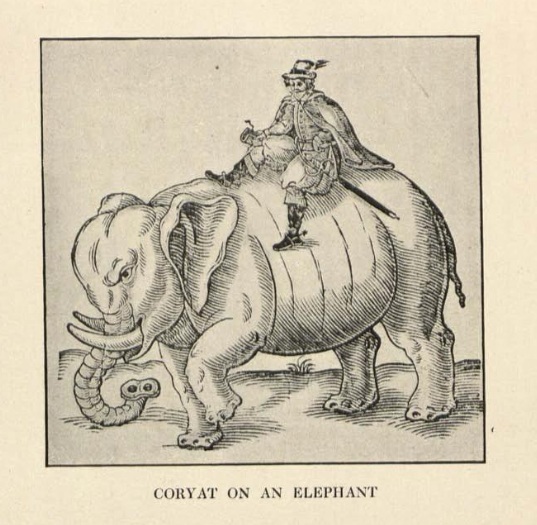
"Coryant on an Elephant"
The illustration “Coryat on an Elephant" (1616), created as a pamphlet cover for the travel accounts of Thomas Coryat, plays a significant role in shaping early modern European perceptions of India. Although the image was not created directly by Coryat, its inclusion alongside his journals contributes to how India was visually interpreted by European audiences. Rather than simply documenting Coryat’s experiences, the illustration presents India as an unusual and visually striking land designed to captivate and intrigue viewers. By emphasizing unfamiliar elements, it reinforces a sense of cultural difference and spectacle. In doing so,the image reflects less about India itself and more about the early modern European perspective and curiosity toward foreign lands. This selective representation helps explain why European audiences became increasingly interested in distant regions, laying the cultural groundwork for expanding overseas trade and economic goals.
Excerpt from "An Essay on the East-India Trade"
During the early modern period, multiple European powers, including England, Spain, Portugal, and France, were engaged in intense competition for economic opportunities. England’s objective within this competition was to increase national wealth by obtaining valuable goods at low cost and reselling them at higher prices in European markets. This process contributed to economic growth, strengthened state finances, and improved stability. With increased wealth, England was able to fund wars and expand its navy, allowing it to protect trade routes, assert dominance at sea, and establish colonies for further economic benefits.
In “An Essay on the East-India Trade” (1696), Charles Davenant enters a contemporary debate over whether trade with India should be restricted or discontinued. At the time, critics argued that such trade harmed England by draining silver and gold in exchange for luxury goods that were perceived as unnecessary. In response, Davenant wrote to challenge those criticisms and defend the value of overseas trade, particularly with the East India trade.
In this excerpt, Davenant presents several arguments to emphasize the importance of trade with India. First, he frames trade as a matter of national importance that should be prioritized by the government, suggesting that any leader who fails to recognize this is “ignorant”. He highlights England’s geographic limitations as an island nation, arguing that it cannot rely on land-based trade and must instead depend on overseas commercial networks. Furthermore, he claims that national strength and security are rooted in wealth, which is generated through well-managed and profitable trade. Finally, he argues that domestic trade alone is insufficient for creating substantial wealth, noting that England’s exports, such as animal products, metals, and agricultural goods, were less profitable compared to the profits of international commerce.
Through these arguments, Davenant demonstrates the significance of trade with India and justifies its continuation. His essay serves as an attempt to influence public opinion and policymakers by presenting foreign commerce as essential to England’s economic success, political strength, and global ambitions. When considered alongside visual representations such as “Coryat on an Elephant”, it becomes clear how both imagery and written argument were relevant in shaping European interest in India, ultimately supporting the expansion of trade and the growth of European empires.
Bibliography
Foster, William, ed. Early Travels in India, 1583-1619. Oxford University Press, 1921. Internet Archive. Accessed April 10, 2026. https://archive.org/details/earlytravelsinin00fostuoft/page/248/mode/1up.
D’Avenant, Charles. An Essay on the East-India Trade. London, 1697. Avalon Project, Yale Law School. Accessed April 2026. https://avalon.law.yale.edu/17th_century/eastindi.asp.
Newfoundland and the Atlantic World
Written by Ryan Cassell
During the early modern period, European countries began expanding across the Atlantic in search of new resources and opportunities. Newfoundland became an important part of this expansion because of its location and its access to valuable fishing grounds. Rather than being important for permanent settlement right away, Newfoundland first gained attention as a place for fishing, trade, and travel across the Atlantic ocean.
This exhibit examines how Newfoundland’s importance developed by looking at three historical maps. Together, these sources show how Newfoundland was valued for its fishing resources, its connection to England, and its strategic position in the North Atlantic. These maps help explain how Newfoundland gradually became more important within England’s growing presence in the New World.
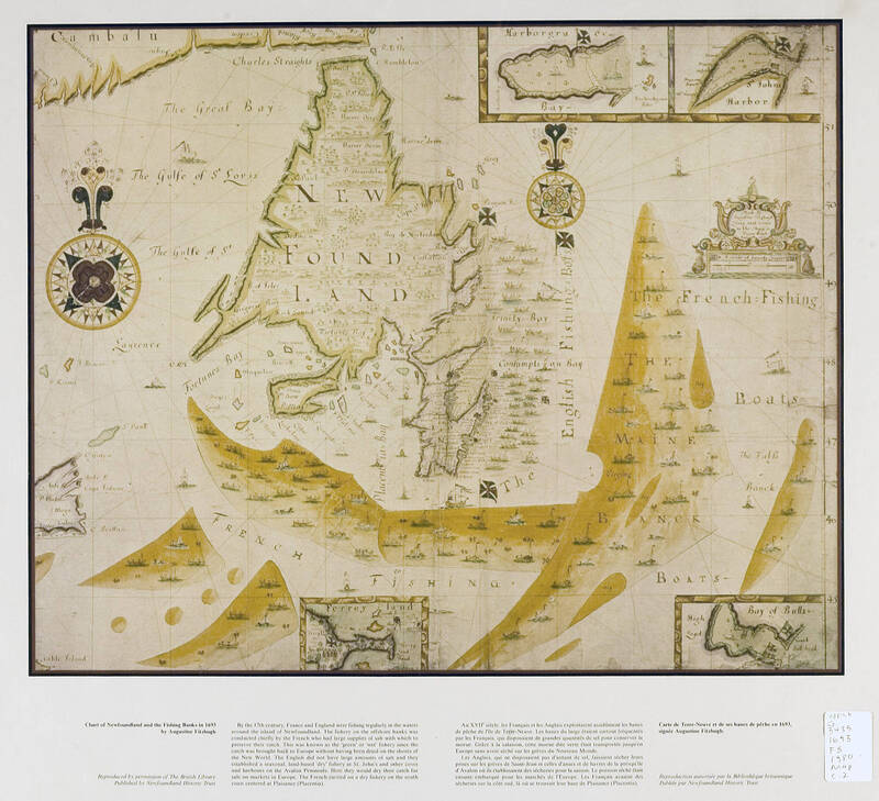
This first map from 1693 focuses on Newfoundland and the surrounding ocean, especially the fishing areas. Large shaded sections in the water represent important fishing grounds, including the Grand Banks of Newfoundland. The map also shows ships and labels such as “English Fishing” and “French Fishing,” which highlight how different European nations were competing between each other over the region's natural resources.
This map shows that Newfoundland was initially valuable because of its large fishing industry. The Grand Banks were one of the richest fishing areas in the world, attracting fishermen from all over Europe. This helps explain why countries like England and France were so heavily interested in the region even before permanent settlements were established. Fishing created regular activity in the area and laid the foundation for future development.
However, the map only reflects a European point of view. It focuses on fishing and competition, but does not show Indigenous peoples or their presence in the region. This suggests that the map was created to highlight economic interests rather than give a complete picture.
Bibliography
Fitzhugh, Augustine. Chart of Newfoundland and the Fishing Banks in 1693. Memorial University Digital Archives. Accessed April 2026. https://collections.mun.ca/digital/collection/maps/id/74/rec/1.
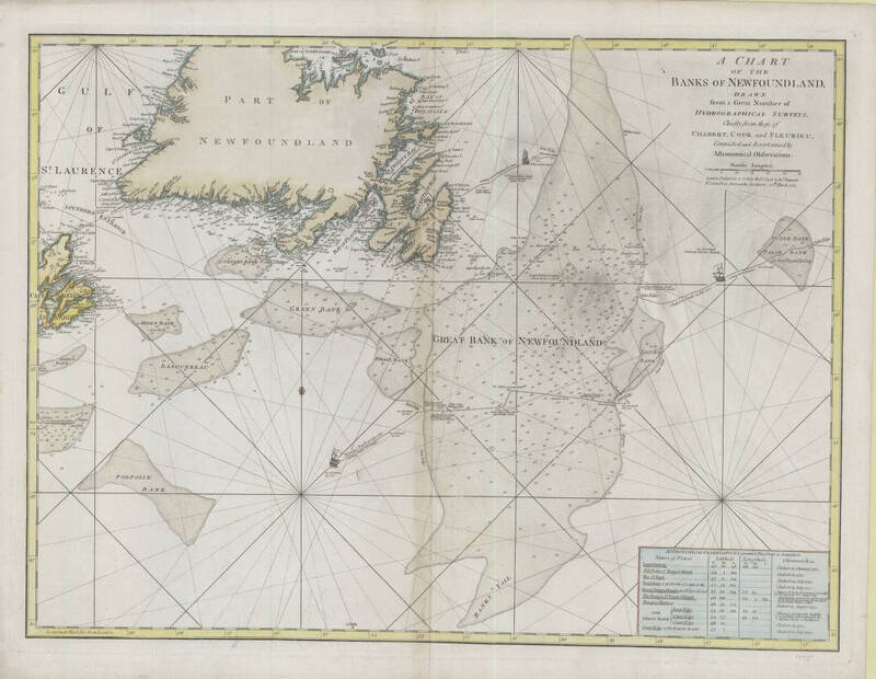
This second map is a detailed chart of the waters around Newfoundland that was drawn from various "Hydrographical Surveys” in 1775. It includes navigation lines, depth measurements, and routes used by ships. One important detail is the drawing of an English ship following a route directly to St. John’s harbour, labeled “Coming from England in June 1746.” This shows that Newfoundland was closely connected to England through regular travel across the Atlantic. Ships were not just visiting once, but making repeated journeys for fishing, trade, and transportation. This helped Newfoundland develop from a seasonal fishing area into a more permanent settlement.
The map also shows how important navigation was during this time. Sailors needed accurate charts to travel safely across the ocean, and in this image at the bottom right it shows the astronomical observations on which this chart is grounded. It highlights how Newfoundland was part of a growing Atlantic network controlled by European powers.
Bibliography
Chart of the Banks of Newfoundland. 1775. Memorial University Digital Archives. Accessed April 2026. https://collections.mun.ca/digital/collection/maps/id/888/rec/25.
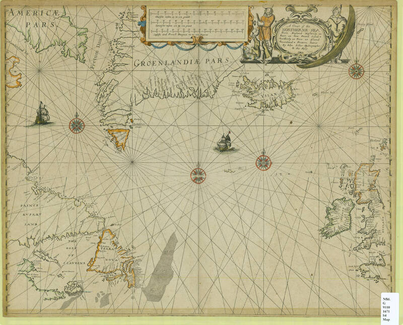
This third map from 1680 shows a wider view of the North Atlantic, including parts of Europe, Greenland, and Newfoundland. Instead of focusing only on the island, it shows a bigger picture and highlights the strategic location of Newfoundland relative to England. Ships are shown traveling across the ocean, and navigation lines help guide long-distance travel. Positioned between England and North America, it became a natural stop for ships crossing the Atlantic. This made it useful for more than just fishing, as it was increasingly being used for communication, trade, and transportation.
By showing the bigger picture and global context, this map helps highlight why Newfoundland mattered so much to European expansion. It demonstrates how Newfoundland was beginning to be viewed as an important part of England's expansion into the New World and not just as a fishing area. Like the other maps, it reflects a European perspective focused on exploration, expansion, and control of the ocean.
Bibliography
Seller, John. A Chart of the Northerne Sea, from England Westerly as Farr as New Found Land and Northerly as Farr as Island Groenland and Fretum Davis. 1671. Memorial University Digital Archives. Accessed April 2026. https://collections.mun.ca/digital/collection/maps/id/313/rec/34.
Maryland Gazette
Written by Isaiah Ogbolu
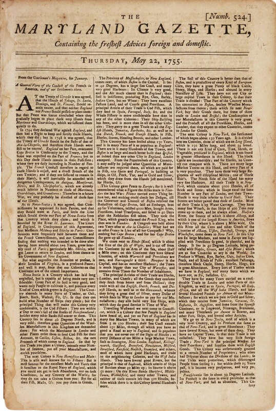
People that read the Maryland Gazette in 1755 had the opportunity to see a reprint of an article called "The State of the English Colonies." As modern day people, we have to go off what has been saved since that time. Originally it was published in London, the article got republished in Annapolis to let colonists know how Britain's Atlantic possessions and products were doing, how much they were worth, and potential future outcomes. The image looks like a report at first because it lists trade, resources, population, and places a strong emphasis on strategies. But looking at it multiple times and reading it more closely, it shows something deeper. It shows how print media made this empire seem normal, and ignored colonial exploitation while educating other readers. And made slavery a part of economic growth.
The Maryland Gazette and other newspapers did more than just share news. They taught people how to think about the colonies not as homes, but as assets. They also connected readers to imperial priorities. The article talks about colonies, how productive, profitable, and useful they are to Britain. Sugar islands, tobacco fields, timber lands, and shipping routes are all parts of one big empire. Even though the image doesn't focus on them very often, enslaved Africans appear as the people who work in this system. Their existence in the history of trade however they get downplayed. They display how slavery became normal by leaving it out instead of explaining it directly to the audience.
It is very important that this text is being reprinted in Maryland. By 1755, the Chesapeake was a huge contributor to trade across the Atlantic because it sent tobacco to other countries that were using slave labor. People in the area didn't need slavery explained to them because it was a part of their daily lives. The article gave people who resided around that area a more clear illustration of the empire by showing them how their local plantation system fits into the bigger picture of the future plan the English had in mind. Print culture became a glue for the empire. It connected colonial identity with the economic goals of the city and made exploitation look logical, planned, and even admirable.
This source also shows how information moved around in the Atlantic world in the 1700s. Ideas moved from printers in London to presses in the colonies, changing people's political views across the oceans. From reading this article, it gives off more of a persuasive tone. It reflects the way the empire was thinking and thought it could control lands that were out of their reach. The text turns human lives and environments into an opportunity to enter colonialist activities by describing colonies in ways that don’t represent the events that took place and sacrifices that were made.
For modern readers, the most notable aspect is what remains unexpressed. There are no conversations about slavery and no discussions about morals, and no recognition of violence. These absences are not random; they show how these systems were pushed. The article's calm, professional tone hides the human cost of empire behind words about trade and order.
This source, "The State of the English Colonies" shows us how the empire justified the exploitation with the text making it look like more of an economical strategy. The Maryland Gazette didn't make a defence on the behalf of slavery. From observing it, the text just assumed it was a regular practice at the time. It didn't argue for colonization as well. It talked about its benefits. By doing this, the text contributed to creating a view of the world that exploitation was just a normal part of life. This text really encourages readers to think carefully and to read between the lines and see how these systems of power have transformed the English Atlantic side.
Bibliography
The State of the English Colonies. 1755. Maryland Gazette, May 22, 1755 (originally published in Gentleman’s Magazine, January 1755). Accessed April 12, 2026. HathiTrust https://hdl.handle.net/2027/mdp.39015020178300.